Today a mini-engagement activity gets underway which will help define the future of the Lanark Road Spaces for people scheme. This is happening because a recent consultation indicated that there was widespread opposition to the scheme, and that the main issue was safety.
To date, the public debate has been dominated by those who either strongly oppose or strongly support the scheme, and many people have been stuck in the middle. The polarisation of the debate in this way is partly due to the Council’s unwillingness to work with the local community to define the aims of the scheme, and co-design the response. The binary nature of the debate means often it can appear that we have to choose between the safety of cyclists and that of vulnerable pedestrians. The reality is that we should be focused on a scheme that treats everyone’s safety as equally important.
We should be aiming for zero accidents, rather than transferring the risk from one group to another (e.g. via floating bus stops!). For this to happen, however, those who either strongly oppose or strongly support the existing setup will have to compromise.
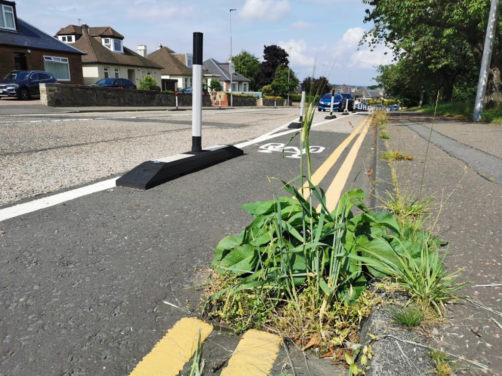
Having looked at the options the Council is using as a starting point (which were approved by Labour, Green, SNP, Independent, Lib Dem and Tory Councillors), the key one impacting on my Ward is just east of Gillespie Crossroads – a short section on the north side of the road between number 432 and Spylaw Park. The concern here is that there is a conflict between parents children accessing Cranley Nursery and passing cyclists. The Council is suggesting the existing lane is retained and floating parking spaces are removed (or vice versa). The existing setup is shown below.
Removing a short section of cycle lane here to reduce the conflict between children and cyclists has been described by one opponent as “ripping out protected cycle space in SW Edinburgh for extra on-street parking“. This is not correct as this is not a protected cycle lane (there are no bollards etc) and there will be no increase in parking. The Council’s argument for removing this short section of cycle lane is “anyone cycling on this section is likely to have cycled in from Lanark Road West and will thus likely be capable of cycling around the parking area”. There is some logic in this argument, but it clearly needs to be explored and challenged as part of the consultation.
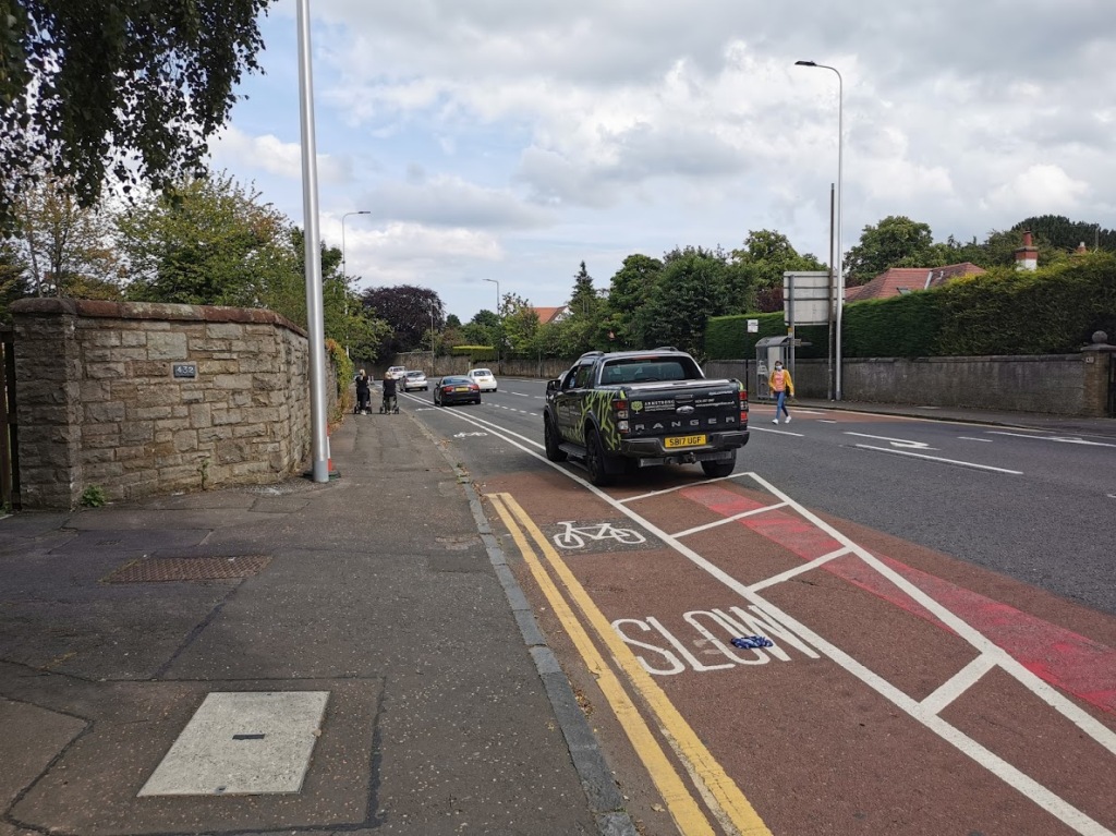
A second issue which the mini-engagement activity will consider is the ‘floating parking’ on downhill sections of the route. This is were the kerb and parking spaces are separated by a cycle lane (see image below). The issue here is that on the downhill sections of Lanark Road there is a risk that somebody alighting from a vehicle may be struck by a cyclist. I rode this section today, and was able to reach 24.4 mph with no real effort. The combination of my momentum and the poor running surface is potentially deadly – and there has already been an accident involving a toddler and an adult cyclist. I have spoken to the wife of the cyclist, and I understand he is strongly opposed to floating parking after his experience. It therefore appears correct, if the lanes are to stay, to consult on moving the parking to the uphill side of the road.
I spent 2 hours (and cycled 30km) looking at the Lanark Road and Water of Leith Walkway today from Inglis Green to Balerno. There’s lots of debate about the future of both, but I hope everyone can agree the running surface on the Lanark Rd cycle lanes is abysmal! Even if the Lanark Road scheme was perfect, however, its success will always be limited.
At its west end the Lanark Road SfP scheme terminates just short of Gillespie Crossroads. The westward Lanark Road is too narrow to include any sort of protected feeder cycle lane (but the footpaths do need widened in places), and is not a comfortable cycling experience (see video – speeded up & normal speed). Those that proposed the scheme believed that cyclists would switch from the Water of Leith Path to the Lanark Road SfP scheme at Colinton. This probably looks great on Google Earth in some distance consultant’s office, but the hill makes it an unlikely proposition in the real world.
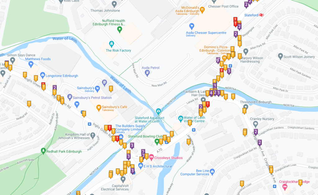
At the east end of the scheme, cyclists are dumped into the Inglis Green Road/Lanark Road/Slateford Road/Craig Lockhart Avenue interchange. This is not fun – CrashMap reports 125 accidents involving personal injuries over the past 22 years (see below).
These connectivity problems to the east and west are perhaps why the strongest supporters of the Lanark Road SfP refuse to say what level of usage would mean it could be called a ‘success’. Of course, there are other ways of measuring success (e.g. accident reduction) – this is something the local community should consider as part of the consultation. Indeed, a longer term plan and timeline from the Council on how Lanark Road SfP can be part of a larger cycle network would also be useful.
Opponents of the Lanark Road SfP will point to the Union Canal Towpath and the Water of Leith Walkway as alternatives for cyclists. My view is that the Union Canal Towpath east of Meggetland should be avoided as it is at capacity. When not busy, however, it is a great route. The Water of Leith Walkway between the Union Canal and Balerno (NCR75) is good but a bell is needed (see video – speeded up & normal speed), and will get better if the plans to improve the surface are realised. Its main drawback is the lack of lighting (not easy to fix), so it does not work as a commuting route over the winter. Indeed, lone cyclists/walkers may not feel safe at any time of day/year.
So if there are limitations on cycling on the broad Lanark Road corridor, how do we cut congestion and reduce emissions along the route? The answer here, as for most of suburban Edinburgh, is public transport. I’d love it if people in Balerno & Currie had a safe cycling route into the city and other places of employment etc, but the reality is that if we are to tackle the climate emergency we have to look to making public transport more attractive. Once the future of Lanark Road SfP is settled, we need to give the same energy to improving public transport.
